Development Authorities
MA & UD Department, Government of Andhra Pradesh

Sri Nara Chandrababu Naidu
Hon'ble Chief Minister of AP
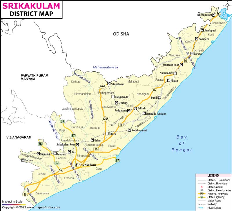
The Srikakulam Urban Development Authority is an urban planning agency in Srikakulam district of the Indian state of Andhra Pradesh. It was constituted on 12 February 2019, under Andhra Pradesh Metropolitan Region and Urban Development Authorities Act, 2016 with the headquarters located at Srikakulam.
It was constituted on 12 February 2019, under Andhra Pradesh Metropolitan Region and Urban Development Authorities Act, 2016 with the headquarters located at Srikakulam. [1] The jurisdictional area of SUDA is spread over an area of 3,824.63 km 2 (1,476.70 sq mi).
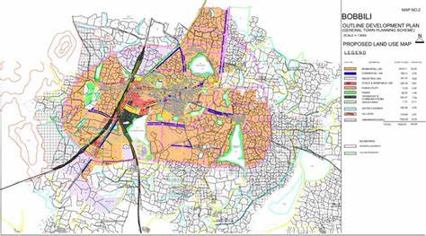
The Bobbili Urban Development Authority (BUDA) is an urban planning agency in Vizianagaram district of the Indian state of Andhra Pradesh. It was constituted on 12 February 2019, under Andhra Pradesh Metropolitan Region and Urban Development Authorities Act, 2016 with the headquarters located at Bobbili.
It was constituted on 12 February 2019, under Andhra Pradesh Metropolitan Region and Urban Development Authorities Act, 2016 with the headquarters located at Bobbili. [1] The jurisdictional area of BUDA is spread over an area of 2,247.67 km 2 (867.83 sq mi) and has a population of 7.52 lakhs.
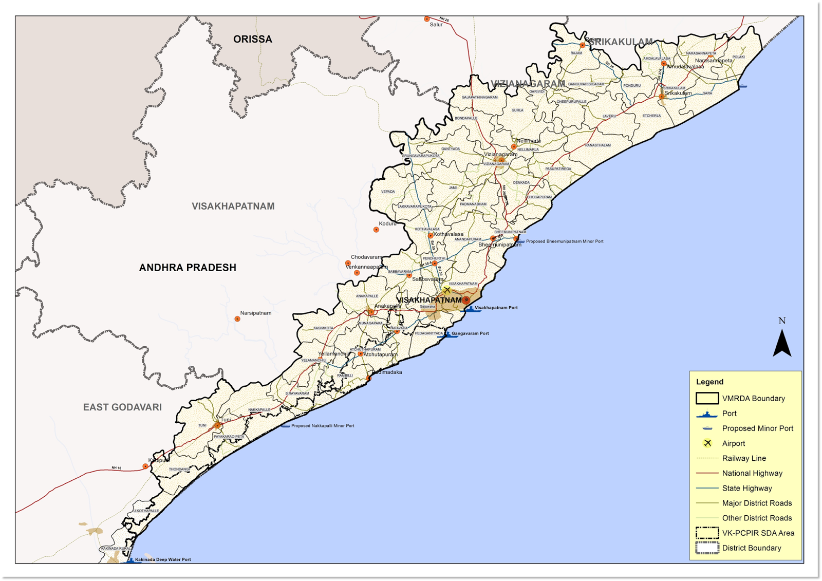
Visakhapatnam Metropolitan Region or Greater Visakhapatnam is the metropolitan area covered by the city of Visakhapatnam in the Indian state of Andhra Pradesh. The entire region is spread over the districts of Visakhapatnam, Vizianagaram and Anakapalli. Under the jurisdiction of Visakhapatnam Metropolitan Region Development Authority
It covers an area of 7,328.86 km2 (2,829.69 sq mi) and has a population over of 60.7 lakhs according to 2011 census.
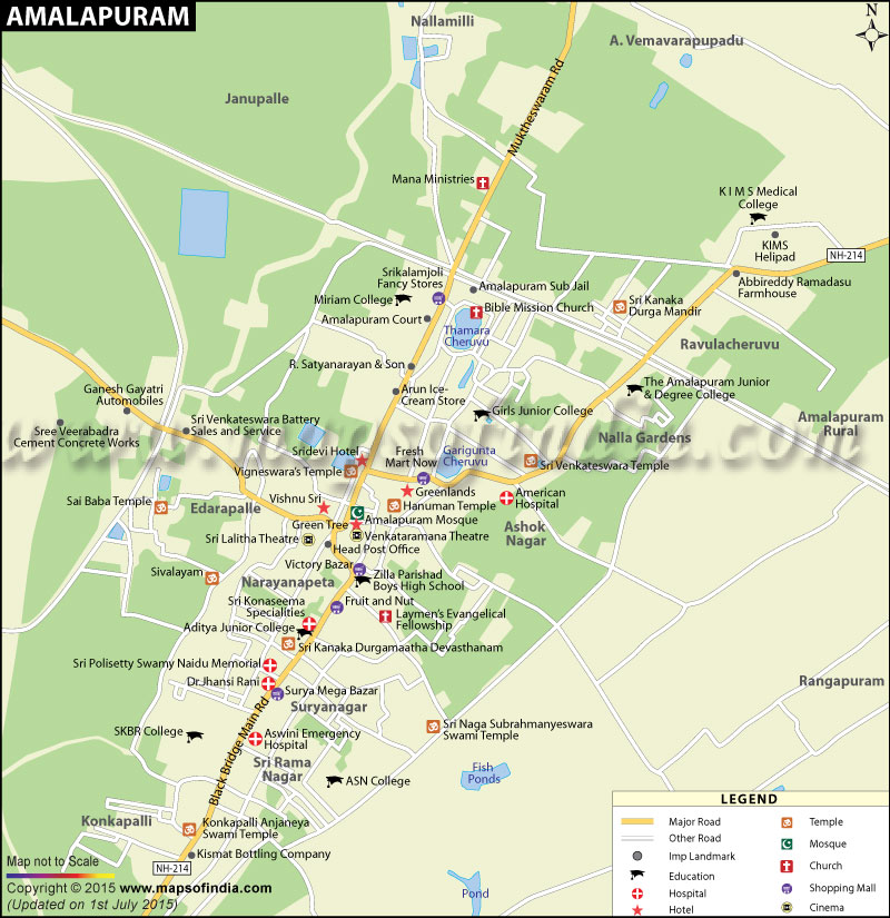
Amalapuram Municipality is 3rd largest ULB in the East Godavari District of Andhra Pradesh. It is spread over an area of 7.02 Sq.KMs. with a population of 53,231 (2011 Census). It is known as KONASEEMA and District Head Quarters.
It is located 520 Kms., from Capital City and 65 Kms., from District Head Quarters. It was established as Amalapuram Municipality in the year 1940. There are 4 zones and 30 Election wards in this Municipality.
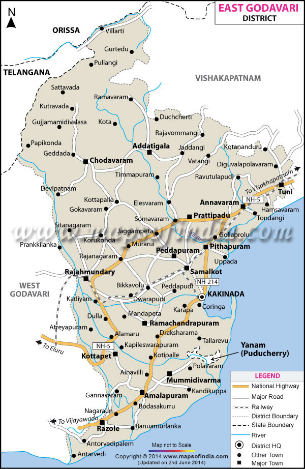
Kakinada district which is newly formed has boundary with Anakapalli district and Alluri Sitaramaraju district on the north, East Godavari district on the south. Konaseema District on South and Bay of Bengal in the East.
There are 2 Revenue Divisions with Head Quarters at Kakinada, Peddapuram. The District consists 21 Revenue Mandals and 21 Mandal Parishads. 385 Gram Panchayats exist in the District. There are 1 Municipal Corporation viz., Kakinada as well as 4 Municipalities samalkot, Pithapuram, Peddapuram, Tuni, 2 Nagar Panchayats, i.e., Yeleswaram, Gollaprolu. As per 2011 Census, this district having 395 inhabited villages, 20 un-inhabited villages. Total population is 20.92 lakhs and the Geographical area is 3020 Sq. Kms. Kakinada District is one of the most populous with density-populated District in the State. The density of Population is 693 per Sq. Km.
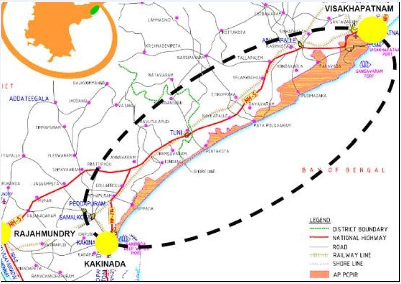
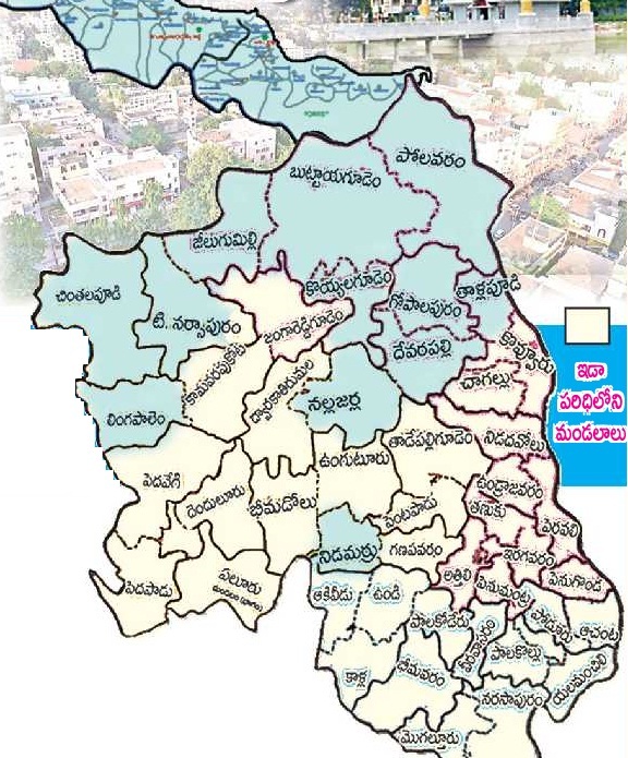
Rajamahendravaram (or Rajahmundry) Urban Development Authority (RUDA) is a Regional and Town Planning organization approved by the state government of Andhra Pradesh in India on 6th August 2021. Its head quarters is located in the city of Rajamahendravaram (Rajahmundry) and includes 207 villages and 3 Urban Local Bodies (ULBs) Kovvur, Nidadavole and Mandapeta in the districts of East Godavari and West Godavari.
The total area of this UDA is 1566.44 sq.km2. The existing Godavari Urban Development Authority (GUDA) in the East Godavari district is denotified and bifurcated into Rajamahendravaram Urban Development Authority (RUDA) and Kakinada Urban Development Authority (KUDA). RUDA also included a few villages from Eluru Urban Development Authority (EUDA) in West Godavari.
The Eluru Urban Development Authority (EUDA) is an urban planning agency in West Godavari district of the Indian state of Andhra Pradesh.[1][2] It was constituted on 1 January 2019, under Andhra Pradesh Metropolitan Region and Urban Development Authority Act, 2016 with the headquarters located at Eluru.[3]
The jurisdictional area of EUDA is spread over an area of 3,327.99 km2 (1,284.94 sq mi).[3] It covers 463 villages in 35 mandals of West Godavari district. The below table lists the urban areas of EUDA.
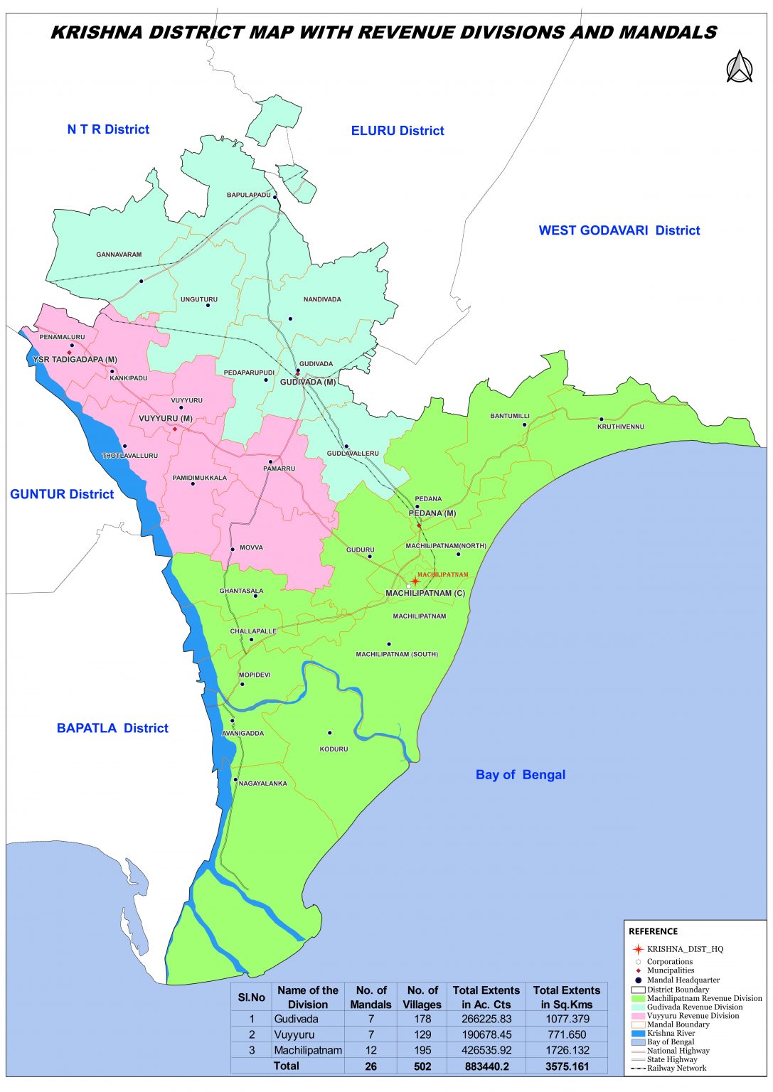
The Machilipatnam Urban Development Authority (MUDA) is a special urban planning authority.[1] It was constituted on 1 February 2016, under Andhra Pradesh Urban Areas (Development) Act 1975. The headquarters are located at Machilipatnam in the Krishna district of the Indian state of Andhra Pradesh.[2]
The MUDA covers a jurisdictional area of 426.16 km2 (164.54 sq mi) which includes, Machilipatnam Municipal Corporation, 27 villages from Machilipatnam mandal and a lone village from Pedana mandal.[2]
Guntur District was formed on the 1st October, 1904 with Head Quarters at Guntur after bifurcating Krishna and Nellore districts.
As per Gazette No. 939, Dated.26th January 2022 the Guntur District was divided into Three Districts i.e., Guntur (18 Mandals), Narasaraopet / Palnadu (28 Mandals) and Bapatla (25 Mandals). 12 Mandals from Tenali Division and 13 Mandals from Prakasam District merged into Bapatla District.
The population of the district is 15,86,918 with a Density of 414 per Sq. Km. The Percentage of literary is 54.70 and the Percentage of Urban population to Total Population is 17.90.
In 1904 Guntur district was constituted into a separate independent district with the areas of the Taluka of Tenali, Bapatla, Guntur, Sattenapalli, Narasaraopet, Vinukonda and Palnadu of old Krishna district and Ongole taluk from Nellore district. With effect from 1st November 1977 again, these eigh taluks were reorganised into eleven taluks by upgrading the sub-taluks of 1) Mangalagiri 2) Ponnuru 3) Macherla as taluks bifurcating the old taluks of Guntur, Bapatla and Palnadu respectively.
The population of the district is 20,41,723 with a Density of 280 per Sq. Km. The Percentage of literacy is 53.19 and the Percentage of Urban population to Total Population is 22.43 The total Geographical area of the District is 7,30,123 Hectares covered by forest is 1,50,759 Hectares. The net area sown is 3,15,650 Hectares. The total cropped area in the District is 3,47,114 Hectares. The area sown more than once during the year is 31,464 Hectares.
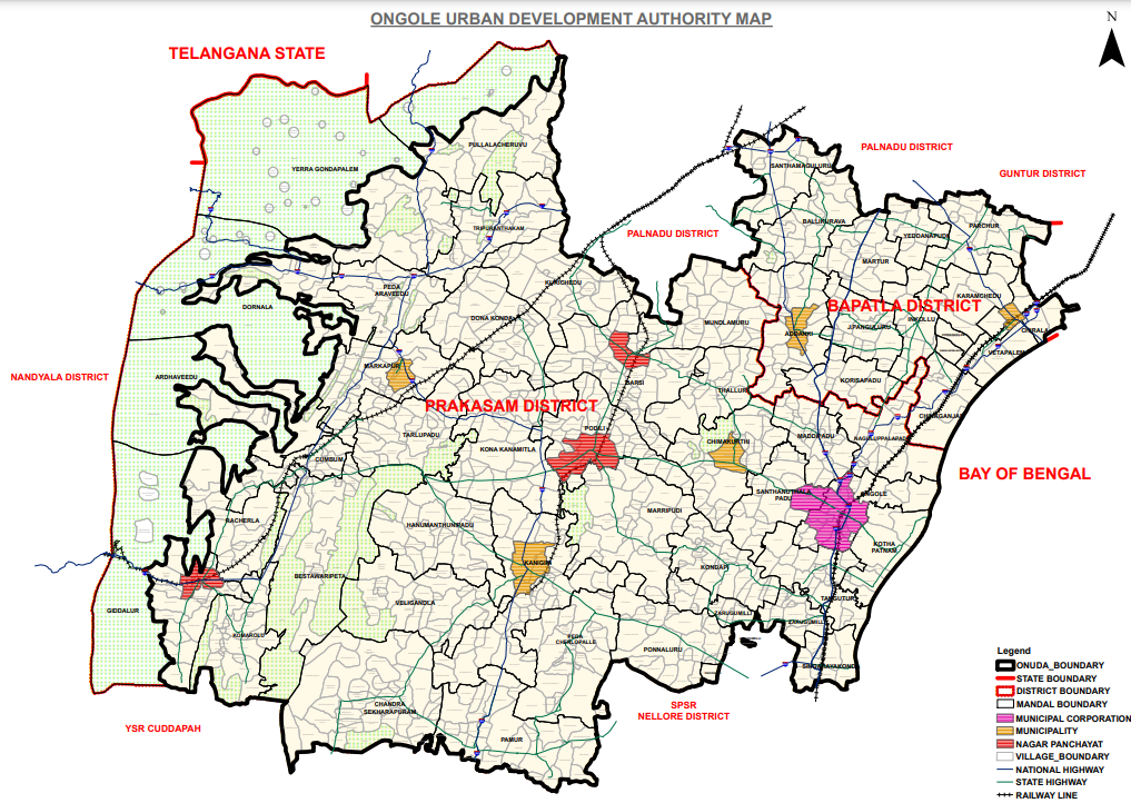
The Ongole Urban Development Authority (OUDA) is an urban planning agency in Prakasam district of the Indian state of Andhra Pradesh. It was constituted on 1 January 2019, under Andhra Pradesh Metropolitan Region and Urban Development Authorities Act, 2016 with the headquarters located at Ongole.
The jurisdictional area of OUDA is spread over an area of 9,320.19 km2 (3,598.55 sq mi) and has a population of 18.24 lakhs.
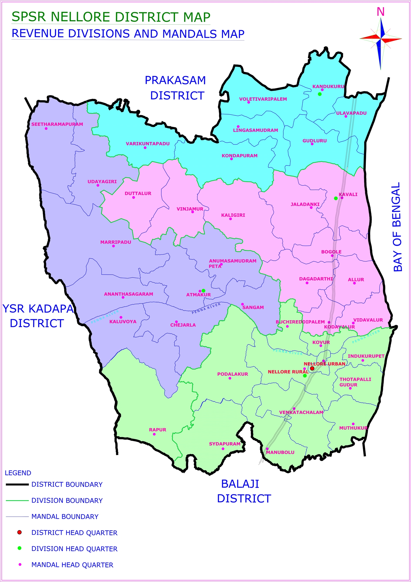
Nellore District situated in the South Eastern portion of the state with a coastal length of 163 KM bounded by Bay of Bengal on the East. The district was known as Vikrama Simhapuri until 13th Century and later it came to be referred to as Nellore
Historically the district was under the rule of Mouryas, Sathavahanas, Pallavas, Cholas, TelugU cholas, Kakateeyas, Pandyans etc. The great Telugu poet Tikkana Somayaji translated 15 parvas of Sanskrit Mahabharata into Telugu in Nellore.
It is supposed that Nellore was situated in Dandakaranya forests into which the Aryas first penetrated as adventurous sages with the rise of the Mouryan Empire Nellore also seems to have under its influence and was part of the Ashoka Empire in the 3rd century B.C. It was next included in the Pallava Dominion between the fourth and sixth century A.D.
Nellore district formed part of the composite Madras State till 1st October, 1953. On 1st November 1956 when the states were reorganized on a linguistic basis, this district came under the Andhra Pradesh State.
The name of Nellore district has been changed as Sri Potti Sriramulu Nellore District on 4th June, 2008.
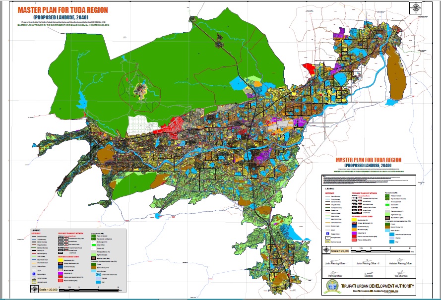
The Tirupati Urban Development Authority, also known as TUDA is a government agency and the principal planning authority for Tirupati and its neighbourhood areas in Tirupati District of the Indian state of Andhra pradesh.
It was notified on 6 November 1981 by the Government of Andhra Pradesh as per Andhra Pradesh Urban Areas Development Act 1975 and is headquartered at Tirupati. At present it covers the jurisdictional area of 4,527 km2 (1,748 sq mi), which covers Tirupati, Tirumala, Renigunta, Chandragiri, Yerpedu, Puttur, Sri Kalahasti, Nagari, Sathyavedu, Karvetinagaram and 160 surrounding villages.
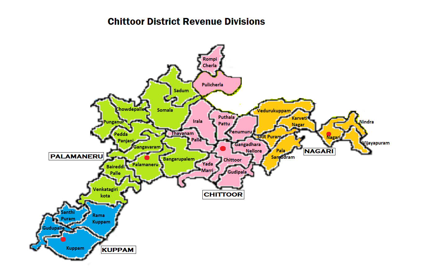
The Chittoor Urban Development Authority (abbreviated: CHUDA) is an urban planning agency in Chittoor district of the Indian state of Andhra Pradesh. It was constituted on 12 February 2019, under Andhra Pradesh Metropolitan Region and Urban Development Authorities Act, 2016 with the headquarters located at Chittoor.
The jurisdictional area of CHUDA is spread over an area of 3,895.58 km2 (1,504.09 sq mi) and has a population of 12,42,315. It covers 457 villages in 23 mandals of Chittoor.[3] The below table lists the urban areas of CHUDA.
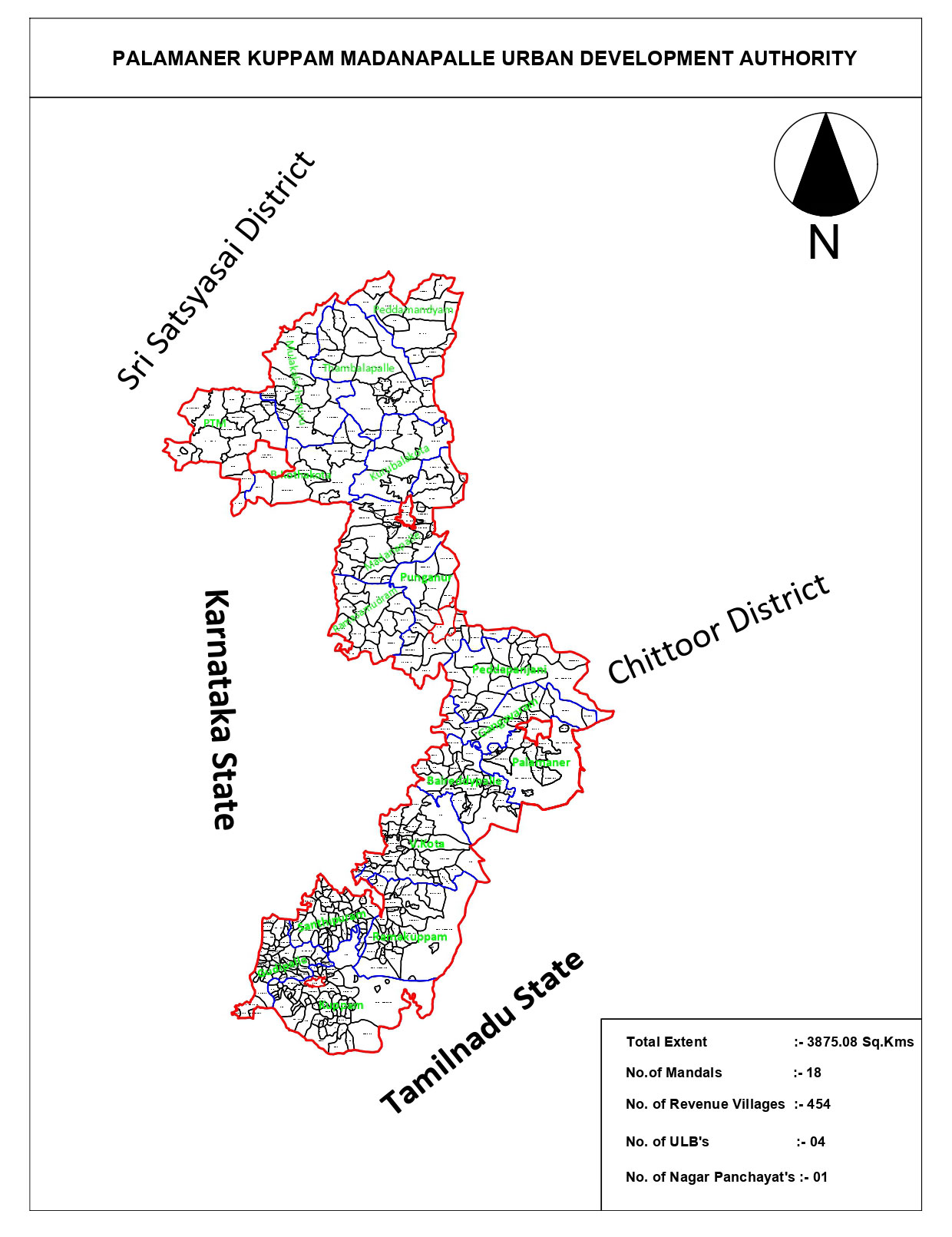
The Government has constituted Palamaner Kuppam Madanapalle Urban Development Authority(PKMUDA) in the year 2019 with an area of 2435.50 Sq.Kms covering three (03) Urban Local Bodies i.e., Madanapalle, Palamaner and Punganur Municipalities and 377 villages in 12 Mandals in Chittoor District (PKMUDA) with Head Quarters at Madanapalle Town in G.O.Ms.No.60 MA& UD (H1) Department Dated 12.02.2019.
Further, the Government issued G.O.Ms.No.110 MA& UD (H1) Department dt.23.09.2021 for inclusion of 79 Villages and 6 Mandals and B.Kothakota Nagar panchayat with an extent of 1439.58Sq.Kms in the jurisdiction of PKMUDA, Madanapalle.
Thus the total extent of PKMUDA is 3875.08 Sq.Kms covering 456 Villages in 18 Mandals and 5 ULBs (Kuppam, Madanapalle, Palamaner, Punganur Municipalities and B.Kothakota Nagar Panchayat).
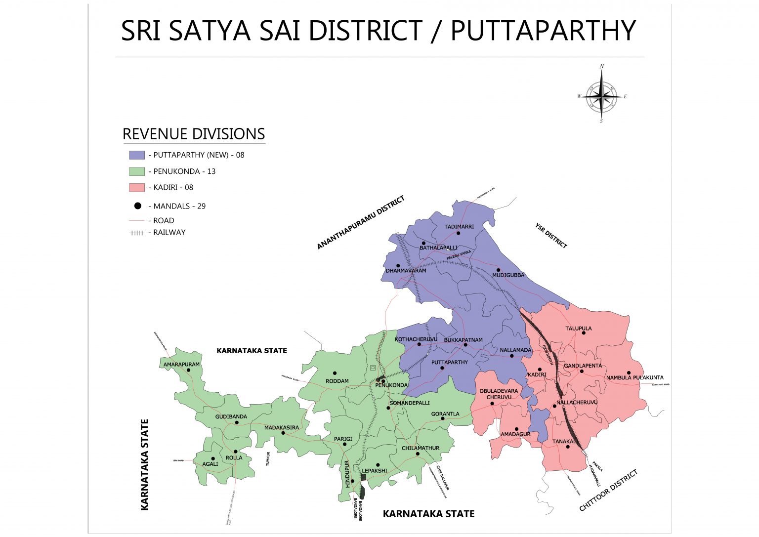
The original name of Puttaparthy was Gollapalli which is situated on the banks of Chitravathi River. The entire area was covered with anthills with snake pits. Gollapalli thus became Puttapalli (village of anthills) and in due course Puttaparthy. Puttaparthy is now adored all over the world as the birthplace of the Avatar of the Age, Bhagawan Sri Satya Sai Baba. Prasanthi Nilayam, the Highest Abode of Peace was constructed in 1950 by the dedicated and loving devotees of Bhagawan Sri Satya Sai Baba, a new movement itself for the regeneration of human society.
Previously Puttaparthy town in Kadiri division is a part of Ananthapuramu District. The Ananthapuramu district was formed in the year 1882 duly separated from Bellary district of Karnataka state. Sri Satya Sai District (Puttaparthy) lies between 13° -40’ and 14°- 6’ Northern Latitude and 76°-88’ and 78°-30’ Eastern Longitude.
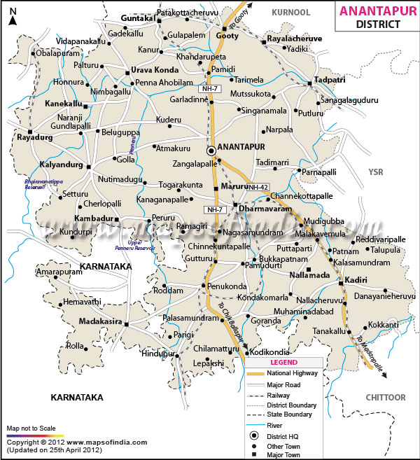
The Anantapuramu–Hindupur Urban Development Authority (AHUDA)[1] is an urban planning agency in Anantapur district of the Indian state of Andhra Pradesh.[2][3] It was constituted on 4 November 2017, under Andhra Pradesh Metropolitan Region and Urban Development Authority Act, 2016 with the headquarters located at Anantapuramu.
The jurisdictional area of AHUDA is spread over an area of 2,791.78 km2 (1,077.91 sq mi).[5] It covers 177 villages in 18 mandals of Anantapur district and newly formed Sri Sathya Sai district. Anantapuram is the only corporation and two other municipalities viz., Hindupur and Dharmavaram are also a part of AHUDA.
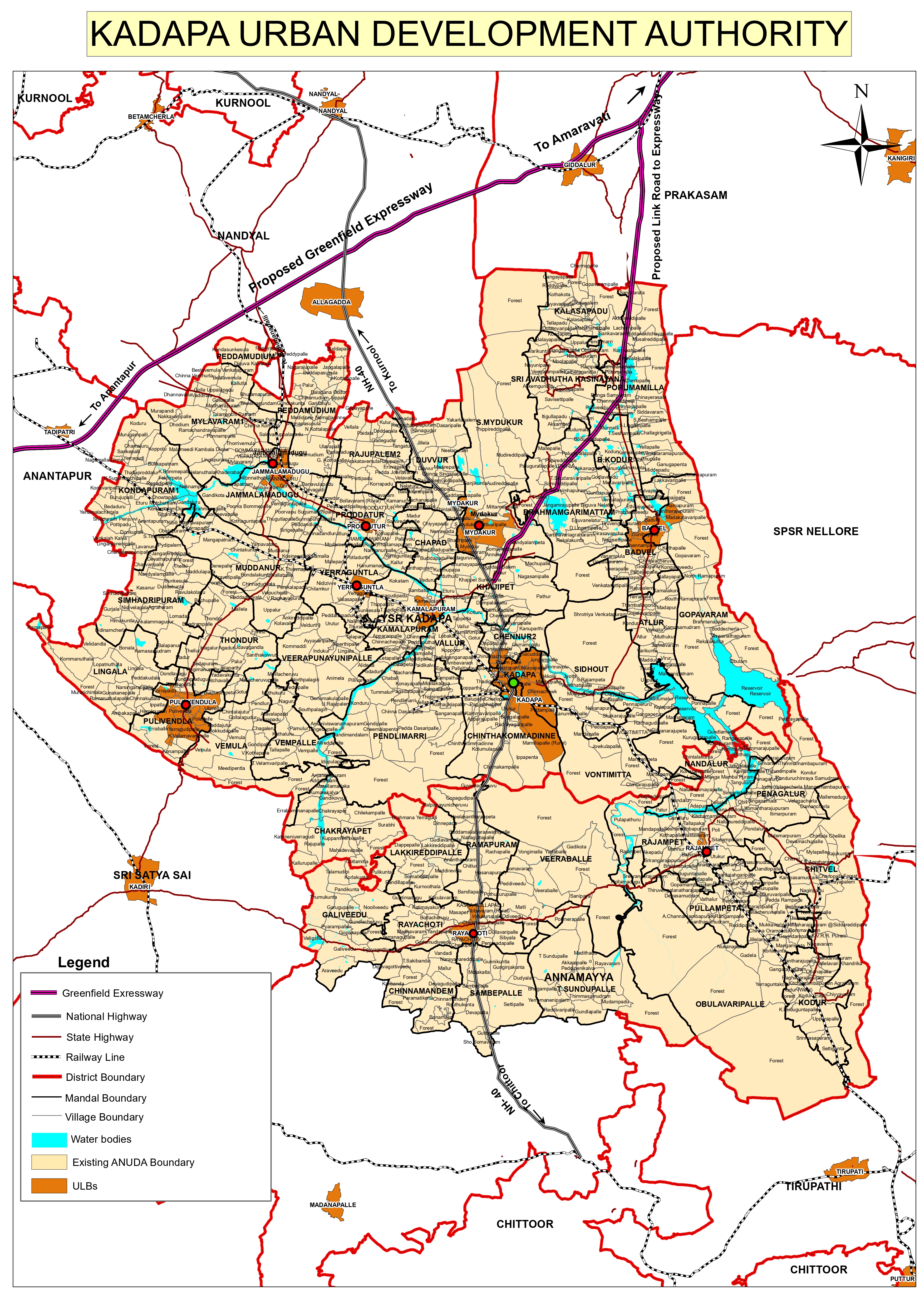
The Annamayya Urban Development Authority (ANUDA)was constituted on 1 January 2019, under Andhra Pradesh Metropolitan Region and Urban Development Authority Act, 2016 with the headquarters located at Kadapa and Annamayya Urban Development Authority (ANUDA) is renamed as “KADAPA URBAN DEVELOPMENT AUTHORITY” by Government of Andhra Paradesh.
The Government vide G.O.Ms.No.2 Dated:01.01.2019 Municipal Administration & Urban Development (H) Department (click here for GO) has constituted Annamayya Urban Development Authority (ANUDA) with Head Quarter at Kadapa with the area of 5392.26 Sq. Kms covering One (1) Municipal Corporation and Nine (09) Municipalities i.e., Kadapa Municipal Corporation, Proddutur, Rayachoti, Mydukur, Badvel, Pulivendula Municipalities, Mydukur, Yerraguntla, Jammalamadugu, Kamalapuram Nagar Panchayats and 339 villages in 39 Mandals in erstwhile YSR Kadapa District.
Further, the Government vide G.O.Ms.No.140 Dated:25.11.2021 Municipal Administration & Urban Development (H) Department (click here for GO) have included 520 villages of 41 Mandals with an extent of 7388 Sq.Kms in the jurisdiction of Annamayya Urban Development Authority (ANUDA). Now, the total extent of Annamayya Urban Development Authority (ANUDA), Kadapa, YSR. District is 12,780.26 Sq.Kms.
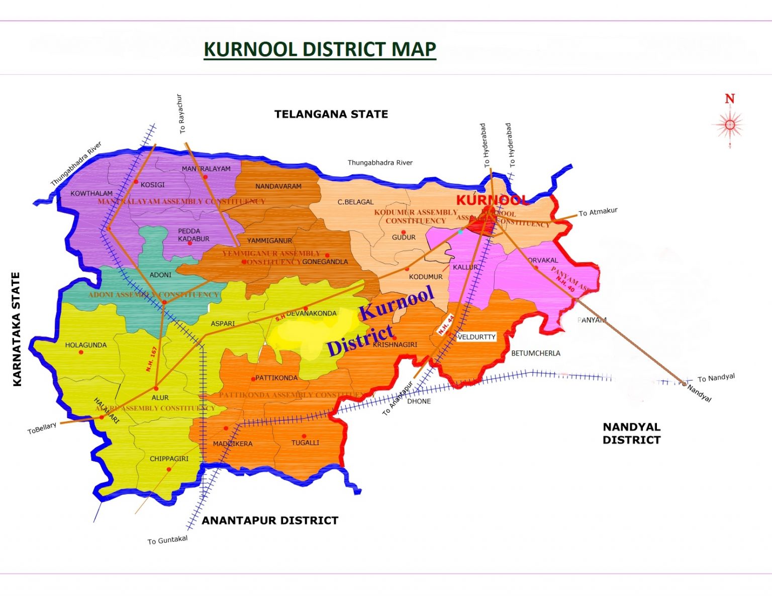
This district derives its name from its chief town Kurnool the capital of former Nawabs, Capital of Andhra Pradesh State from 1st October 1953 to 1st November, 1956 and at present the headquarters of the district. The name Kurnool is said to have been derived form “Kandanavolu”.
Kurnool District lies between the northern latitudes of 140 54’ and 160 18’ and eastern longitudes of 760 58’ and 790 34’. The altitude of the district varies from 100 ft above the mean sea level. This district is bounded on the north by Tungabhadra and Krishna rivers as well as Mahabubnagar district of Telangana State, on the south by Anantapur District on the west by the Bellary district of Karnataka State and on the east by Nandyal District. The population with 22,71,686 People accounting for as per 2011 Population Census, while in area with 9681 Sq. Kms.
The Urban Development Authorities Department, Andhra Pradesh, serves as the nodal planning and regulatory framework for urban development across the State. The Department oversees and guides multiple Urban Development Authorities (UDAs) to ensure planned, sustainable, and integrated urban growth.
With rapid urbanization, the Department plays a vital role in shaping cities and towns into well-organized, infrastructure-enabled, and citizen-centric urban spaces that support economic growth and improved quality of life.
The Department works in alignment with Government policies and statutory planning provisions to regulate land use, approve developments, and facilitate infrastructure creation in urban and peri-urban areas.
First act enabling the constitution of UDAs in the State & 5 UDAs constituted
Enacted exclusively for the constitution of APCRDA for development of capital region.
Superseded the APUDA Act, 1975 and provides for constitution of UDA's
| Financial Powers delegated | UDA |
|---|---|
| Vice Chairperson | Upto 0.5 Cr |
| Executive Committee | 0.5 – 5 Cr |
| Authority | 5 – 50 Cr |
| Government | Above 50 Cr |
| Financial Powers delegated | MRUDA |
|---|---|
| Metropolitan Commissioner | Upto 1 Cr |
| Executive Committee | 1-10 Cr |
| Authority | 10-100 Cr |
| Government | Above 100 Cr |